Saturday, July 21, 2007

Gaiagi Photo Explorer

The Gaiagi Photo Explorer shows photos from flickr and Panoramio tagged with geo locations on Google Maps. It has a convenient interface to zoom into locations of photos as well as links to the original photo pages at the photo services.

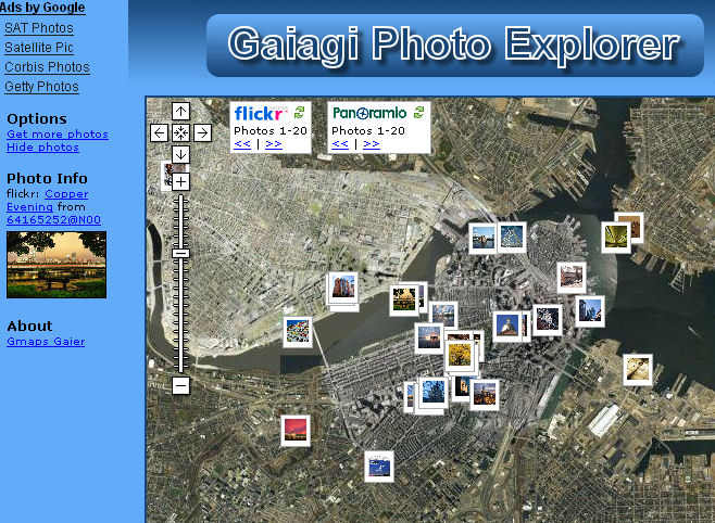
You can move from one photo to the next easily and load new photos for the map area selected. Local search from Google enables to easily select a new location and display a brand new set of photos.


Please let us know your comments and suggestion how to improve the service.

Monday, May 07, 2007

US Weather Radar Gadget Update

The new update includes:
  • Instant weather forecast via insert with icons. Hover over the icons to get a detailed forecast
  • Stored locations of the weather forecast inserts as well as map location and zoom
  • Options to scale the size of the content of the weather forecast insert
  • Option to show the timestamp of the last update of the Radar overlay
  • Options to hide the inserts
Update: We also added:
  • Live Weather cams in the area around the selected ZIP code. Not every weather station has its own webcam.
  • Video weather forecast (Vidcast) from Weatherbug.com.
  • Option to change the weather station. With the Chg button next to the weather station name in the insert the weather stations in the area are displayed on the map. Clicking on a weather station selects the new weather station and saves it for future.
  • Fixed: The map did not recenter to the stored location for modules with a height greater 200. This is fixed now.
  • Display of earthquakes from the last 24 hours. The default is to hide earthquakes below magnitude 5.0 so the display does not get cluttered.
  • Optional display of traffic status for selected cities. Default is not to show the traffic overlay so display stays uncluttered.
  • Support for KML and GeoRSS-Overlays is now also available. KML-Collections can be found at e.g. http://en.wikipedia.org/wiki/Keyhole_Markup_Language. FYI: right now sometimes image overlays don't work.
    You can specify an overlay by the link to e.g.
    • NWS Weather Warnings
      http://wdssii.nssl.noaa.gov/geotiff_new/nws_warnings.kmz
    • Hurricane live positions
      http://www.glooton.fr/hurricanes.kmz
    • Flights approaching different airports: http://www.fboweb.com/antest/ge/geSFO.kmz (San Francisco)
      http://www.fboweb.com/antest/ge/geBOS.kmz (Boston)
      http://www.fboweb.com/antest/ge/geJFK.kmz (JFK - New York)
      http://www.fboweb.com/antest/ge/geLAX.kmz (Los Angeles)
      http://www.fboweb.com/antest/ge/geATL.kmz (Atlanta)
      http://www.fboweb.com/antest/ge/geORD.kmz (Chicago)
      http://www.fboweb.com/antest/ge/geSEA.kmz (Seattle)
      http://www.fboweb.com/antest/ge/geMIA.kmz (Miami)
  • Option to change the location of the weather forecast. Click on the "ZIP" link or on one of the forecast icons in the weather forecast overview. Enter a location or ZIP in the field and hit "enter" to change to the new location displaying the new weather forecast and weather station

Sunday, March 25, 2007

"MyView" had to be removed because of traffic

Because of the high traffic generated by the "MyView" on the NRLSSC server the feature showing different views like IR Satellite, Wind, ... had to be removed. We are searching for an alternative. If you know of alternative sources please send us an email.