Monday, December 11, 2006

US Weather gadget update

We updated the US weather gadget for Google home pages. New features are
  • You can choose among many different overlays when selecting the "MyView" tab (e.g. IR Satellite, VIS Satellite, ice, snow and snow warning, 24h precipiation, ...)
  • height of the module is now configurable
  • minimize the weather station - click on the small arrow in the upper left corner
  • zooming by double-click (left zooms in, right zooms out)
Please let us know if there is a feature which you would like to see.

Update: Because of the high traffic generated by the "MyView" on the NRLSSC server the feature showing different views like IR Satellite, Wind, ... had to be removed. We are searching for an alternative.

Thursday, November 02, 2006

Weather Module: present weather conditions as insert

Now the Weather Module features additional content by WeatherBug: Present weather conditions in two presentations.

Selecting a ZIP for local weather will also trigger the display of a insert showing present weather conditions. Clicking the Station ID will show a larger weather info. You can close this again by hitting the "close" link at the top of the insert.

You can see the new version active further below this page in a sample of the standalone Google Gadget feature.

Comments:
  • Changing the station is not supported until now - will be in the next release. Right now the station is defaulted from the ZIP entered.
  • You can drag the weatherbug window (at the white areas) to the place you want it to be. This also the case e.g. for the weather forecast.

Monday, October 16, 2006

US Weather Radar Module updated

This update of the US Weather Radar Module offers the following new features:
  • Choosing the background of the radar view. You can select between the normal map, the satellite image and the road/border overlay from the hybrid view.

  • Selecting the opacity of the radar view. This does not work too well with Internet Explorer because of limitations of IE.

  • Display of wind directions is now an option in the configuration section. Default is to show wind directions.

  • Triggering the reload of the map.
  • The update covers the expressed need of several users to see the borders between land/sea better. Now you can choose what the underlying images should be.

    Please let us know your comments and suggestions for improvements!

    Tuesday, October 03, 2006

    Google Gadgets on every webpage

    An interesting step ... putting Google Gadgets on every webpage.

    Please see above for an example.

    Get the code for the US Weather Radar on your website.

    Saturday, April 01, 2006

    US Weather Radar as Google Homepage Module


    The GMaps US Weather Radar Module shows the present precipitation situation as detected by the Nexrad Radar system.

    If you enter a ZIP in the configuration section of the module the local weather forecast is shown if you click on "Local Weather".

    Here is a link to directly add the module to Google Homepage.

    Using data provided by the Iowa State University Department of Agronomy and Weatherbug. More information about Nexrad is here.

    Saturday, February 25, 2006

    GMaps Flight Tracker as Google Homepage Module


    Gmaps Flight Tracker now available as Google Homepage Module.

    If you have a flight number available of a flight right now in the air to one of the airports ATL, BOS, JFK, LAX, ORD or SEA you view this flight in your Google Homepage. Just enter the flight number (e.g. AAL222) in the preferences field and watch the location of the plane. Or choose a flight from the list of present flights offered by the module.

    You also can select a picture of e.g. your beloved partner flying right now to be displayed instead of the airplane icon.

    It seems that the timeouts of the Google Homepage proxies are quite short so sometimes the information is not reachable.

    Here is a link to directly add the module to Google Homepage.

    Please let us know your feedback and suggestions: GMapsGaier+GHP at gmail dot com

    Using data provided by fboweb.com.

    Friday, February 03, 2006

    GMaps Flight Tracker - V1.2 beta

    Imagine you have been looking out of the window of the airplane and spotted a beautiful place - and you would like to know where that was.

    If you don't have your GPS-receiver with you to hold it to the window to mark the location (or no internet connection in the airplane) you have the chance to just remember the time. When you have access to the internet again you check gmapsflighttracker.com to locate your flight and move to the time where your flight was at that position.

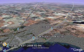
    In addition we offer Google Earth support for these airplane traces. Just right-click the "Download GE kml"-Link, save the file to disk and fire up Google Earth to display past flights including height profiles!

    The new version shows a beta preview of this feature for some selected flights to Boston.

    Above is a screenshot of GE showing flights of AAL222 in Google Earth near Los Angeles.

    Misc additions:
    • Cheapest Fare information. Click on a flight in the menu on the left to show information about cheap fares for the selected flight. You have to enable this service in the "controls". Using data provided by http://www.farecompare.com/
    • Support for zooming the map using the mouse scroll wheel
    • Tracking of a flight (small "T") leaves a trace of the flight
    • Nexrad support. Shows present precipitation. We are working on showing the flight locations more visible when using the Nexrad type. Using data provided by the Iowa State University Department of Agronomy. More Information about Nexrad is here

    Saturday, January 28, 2006

    GMaps Flight Tracker - V1.1

    The new version 1.1 supports
    • Tracking of airplanes (click on the small "T" near the plane in the left navigation section). The selected airplane will be the new center for the maps - also after reloading of data
    • Auto-Loading of new data - this is the new default and can be disabled in "Controls"
    • Direct links to Air Traffic Control (ATC) audio streams (click on the small arrow next to the airport to see the additional menu; only available for Boston, JFK and Los Angeles; sometimes these streams are down or you have to try 2 -3 times until you get a connection)
    GMaps Flight Tracker was featured e.g. at

    Saturday, January 21, 2006

    GMaps Flight Tracker - first version released

    Today we released the first version of GMaps Flight Tracker.

    GMaps Flight Tracker shows incoming flights for some busy US airports (Atlanta, Boston, ...) using data provided by fboweb.com. The data provided is based on position reports for each aircraft in general once per minute.

    We are working on full Internet Explorer support (showing waypoint information in a fast way- anyway the over-all performance with Firefox is better right now so feel free to use Firefox for a great Flight Tracker experience.