A feature which has been requested by many is to be able to specify multiple waypoints for the route. This e.g. is interesting in cases where the directions given by Google do not fit the needs and travel a different route than the intended one.
Waypoints now have been added to Real Indoor and can be found in the directions interface:
Thursday, December 29, 2011
Friday, December 23, 2011
"Let it snow" - on your webpage
Googles latest easter egg: If you search for "let it snow" your screen will become foggy from all the snow coming down.
Here is an explanation how to use the slightly modified javascript to have it snow on your webpage as well. The following code goes into your html-file - best at the end of your content before the "</body>" tag :
Update: You need to include the Google JS api to have the "google"-environment available. Please add your API-key which you can get in the Google API-Console. The script tag should be added in the head section:
<script type="text/javascript" src="https://www.google.com/jsapi?key=INSERT-YOUR-KEY"></script>
Here is an explanation how to use the slightly modified javascript to have it snow on your webpage as well. The following code goes into your html-file - best at the end of your content before the "</body>" tag :
<script type="text/javascript" src="https://www.google.com/jsapi?key=INSERT-YOUR-KEY"></script>
<div id="gbqfb" style="z-index: 1000;"></div>
<div id="snfloader" style="visibility: hidden;"></div>
<script id="snfloader_script" type="text/javascript">
(function(){
var s=document.createElement('script');
s.src='snfog.js'; s.type = 'text/javascript';
s.async=true;
s.addEventListener('load',function(){console.log("snow loaded");
var app = new goog.egg.snowyfog.Snowyfog();app.init();},false);
document.getElementById('snfloader').appendChild(s);})();</script>
The snowyfog-mod.js (you can just save it with right click from here) goes into the same directory as your html file.
Update: You need to include the Google JS api to have the "google"-environment available. Please add your API-key which you can get in the Google API-Console. The script tag should be added in the head section:
<script type="text/javascript" src="https://www.google.com/jsapi?key=INSERT-YOUR-KEY"></script>
Here is the example page with minimal requirements: Let it snow!
When opening your page it will slowly go foggy. After a while a button called "Defrost" will appear and all the fog will be removed after clicking. Snowflakes will continue to fall. Try it out.
Thursday, December 22, 2011
New Simulator "Real Indoor" with Physics Engine
Based on the successful Gaiagi Driver we have pushed the limits of online driving simulation to create Real Indoor.
Real Indoor is dedicated to create a realistic biking experience while working out on spin bikes or similar devices.
Streetview panoramas and the physics engine provide feedback which simulate driving on a real track.
Tracks from bicycle directions, GPS recordings or just following Streetview panoramas allow for a whole new experience while working out and seeing the Earth.
Use Real Indoor to prepare yourselve for that bike summer trip into the mountains - slopes, physics and views all realistically simulated.
Predefined tracks offer a jump start into working out in the real world:
Enjoy the Earth with Real Indoor and have fun biking!
Friday, September 09, 2011
Gaiagi Driver - Updates 2011
New features added recently to the Gaiagi Driver:
- The car speed can manually controlled via a slider
- Condense controls into a small driving control in the upper left where you can pause, stop, continue driving; also the speed is displayed in the control
- Physics mode: to support indoor biking/spinning bikes a bike has been added which moves with real speed based on the applied power. You can control the power you want to spend on your bike and the driver will move accordingly based on weight, slope of the track, ...
- New vehicles added: Motorhome, Camper, Ferrari, Porsche, Ducati, BMX bike, Woman with bike, Millenium Falcon ;-)
- Configurable Icon which displays the location on the map
- Show Panoramio Pictures instead of Birds View in the lower right
- Saving own tours: You can create a tour and store this on your computer to later load the tour again
- Support for speech input on Chrome browsers
- Draggable start and end points. Just adapt your route by dragging the start and end points on the Google Map.
Tuesday, March 16, 2010
Gaiagi Driver - Updates 2010
New features added recently to the Gaiagi Driver:
- Text-to-speech of directions: if you are using Google Chrome you can enable the driver to read the next leg of the directions - just click on the loudspeaker icon appearing in the upper right of the directions to enable reading the directions
- House value Zestimate: when panning the Google Earth view or the Google Map the Location information will show you a "Zestimate link". This will retrieve Zillow.com house values and display in a separate window.
- The location information will as well show the option to retrieve incident data for the present viewport of the Google Map. This feature is leveraging a service from mapquest .
The Gaiagi Driver is available at http://www.gaiagi.com/3d-driving-simulator/.
Sunday, October 18, 2009
US Weather Radar Gadget - Issue with centering on Kansas
Due to an incompatible change in the geocoding API of Google we are facing difficulties with mapping ZIP-codes to geo-coordinates. A fix was introduced which should be active in the latest Us Weather Radar Gadget.
Some instances might have cached the Weather Radar gadget. Helpful is the following gadget from Google which enables you to control caching behaviour of gadgets:
Please let us know if you still have issues after turning off caching of the gadget. If it is working for you you can turn off caching again.
Update Oct. 20th: The issue with the Google geocoder is still not solved. We did further modifications to the geocoding process using 3 different geocoder now and will track results and issues. For us it is working so we need feedback if you have trouble even after turning off caching.
Saturday, April 11, 2009
Gaiagi Driver - Updates 2009
New features added recently:
- Sightseeing Tours: you can select a sightseeing tour from a predefined list of tours like "New York: Central Park to Time Square", "San Francisco: Market Street to Golden Gate", "Rome: Collosseum to Monumento Vittorio Emanuele II", .... Tours can also be saved via a link and shared with others.
- Select your car: Gaiagi Driver now offers to select your car. You can e.g. drive a Porsche, US Police Car, ... and even a UK Bus. Modells are from the Google 3D warehouse and created by Antics and others. Please check the config section for details. If there is interest we can offer to select your own car in "kmz"-format via an URL specified.
- Radio: You can turn on the radio in the config section. Every car needs a radio ...
Tuesday, October 07, 2008
Gaiagi Driver - Driving Simulator including Streetview and Birdsview
The driving simulator follows the path created by the directions and shows the present position in different views. Following views are available:

Other features include navigation in the Google Earth or Google Maps view while other views are adjusted accordingly, controlling of road overlay in earth view, buildings overlay in earth view, traffic overlay in maps view etc. You can easily share the current view with others.
Test drive Gaiagi Driver (Google Earth plugin required; you will be asked to install it if you have not done so).
- upper left: Google Earth view
- upper right: Google Map view. You can toggle traffic information as well as street view information as overlays.
- lower left: Google Streetview
- lower right: Microsoft Birdsview

Other features include navigation in the Google Earth or Google Maps view while other views are adjusted accordingly, controlling of road overlay in earth view, buildings overlay in earth view, traffic overlay in maps view etc. You can easily share the current view with others.
Test drive Gaiagi Driver (Google Earth plugin required; you will be asked to install it if you have not done so).
Sunday, March 16, 2008
US Weather Radar Gadget Updates 2008
New features added recently:
- 1 click weather: just click on the map to get local weather information
- IR Clouds: Clouds overlay based on infrared satellite images as part of the Radar tab
- Wind Movie: 6 day wind flow forecast from meteoblue.com
- May 29: Added Google Earth Plugin support which is yet experimental as it does not support all of the functionality offered by Google Maps like changing the height of the Gadget or supporting overlays the same way as Google Maps does. Update: To test the present functionality you can enable the GE Plugin in the configuration settings.
- July 11: The gadget now supports opacity control of the cloud overlay as well.
- August 23: If no ZIP is configured the weather is shown for your local geographic location derived from the IP address. An additional configuration parameter enables to automatically center the map on the geographic location.
If you are travelling this lets you always view the weather information for your local area as well as optionally have the map centered on your present location. - October 18: support for canvas view in iGoogle
Friday, February 29, 2008
More about NEXRAD - the Doppler Weather Radar detecting present rainfall
Part of the information shown by the Weather Radar Module are NEXRAD weather radar echo graphics. Here you can find more information about the radar technology and meaning of the colors in the radar overlays:
Saturday, July 21, 2007
Gaiagi Photo Explorer
The Gaiagi Photo Explorer shows photos from flickr and Panoramio tagged with geo locations on Google Maps. It has a convenient interface to zoom into locations of photos as well as links to the original photo pages at the photo services.
You can move from one photo to the next easily and load new photos for the map area selected. Local search from Google enables to easily select a new location and display a brand new set of photos.

Please let us know your comments and suggestion how to improve the service.
You can move from one photo to the next easily and load new photos for the map area selected. Local search from Google enables to easily select a new location and display a brand new set of photos.
Please let us know your comments and suggestion how to improve the service.
Monday, May 07, 2007
US Weather Radar Gadget Update
The new update includes:
- Instant weather forecast via insert with icons. Hover over the icons to get a detailed forecast
- Stored locations of the weather forecast inserts as well as map location and zoom
- Options to scale the size of the content of the weather forecast insert
- Option to show the timestamp of the last update of the Radar overlay
- Options to hide the inserts
- Live Weather cams in the area around the selected ZIP code. Not every weather station has its own webcam.
- Video weather forecast (Vidcast) from Weatherbug.com.
- Option to change the weather station. With the Chg button next to the weather station name in the insert the weather stations in the area are displayed on the map. Clicking on a weather station selects the new weather station and saves it for future.
- Fixed: The map did not recenter to the stored location for modules with a height greater 200. This is fixed now.
- Display of earthquakes from the last 24 hours. The default is to hide earthquakes below magnitude 5.0 so the display does not get cluttered.
- Optional display of traffic status for selected cities. Default is not to show the traffic overlay so display stays uncluttered.
- Support for KML and GeoRSS-Overlays is now also available. KML-Collections can be found at e.g. http://en.wikipedia.org/wiki/Keyhole_Markup_Language. FYI: right now sometimes image overlays don't work.
You can specify an overlay by the link to e.g. - NWS Weather Warnings
http://wdssii.nssl.noaa.gov/geotiff_new/nws_warnings.kmz - Hurricane live positions
http://www.glooton.fr/hurricanes.kmz - Flights approaching different airports: http://www.fboweb.com/antest/ge/geSFO.kmz (San Francisco)
http://www.fboweb.com/antest/ge/geBOS.kmz (Boston)
http://www.fboweb.com/antest/ge/geJFK.kmz (JFK - New York)
http://www.fboweb.com/antest/ge/geLAX.kmz (Los Angeles)
http://www.fboweb.com/antest/ge/geATL.kmz (Atlanta)
http://www.fboweb.com/antest/ge/geORD.kmz (Chicago)
http://www.fboweb.com/antest/ge/geSEA.kmz (Seattle)
http://www.fboweb.com/antest/ge/geMIA.kmz (Miami) - Option to change the location of the weather forecast. Click on the "ZIP" link or on one of the forecast icons in the weather forecast overview. Enter a location or ZIP in the field and hit "enter" to change to the new location displaying the new weather forecast and weather station
Sunday, March 25, 2007
"MyView" had to be removed because of traffic
Because of the high traffic generated by the "MyView" on the NRLSSC server the feature showing different views like IR Satellite, Wind, ... had to be removed. We are searching for an alternative. If you know of alternative sources please send us an email.
Monday, December 11, 2006
US Weather gadget update
We updated the US weather gadget for Google home pages. New features are
Update: Because of the high traffic generated by the "MyView" on the NRLSSC server the feature showing different views like IR Satellite, Wind, ... had to be removed. We are searching for an alternative.
- You can choose among many different overlays when selecting the "MyView" tab (e.g. IR Satellite, VIS Satellite, ice, snow and snow warning, 24h precipiation, ...)
- height of the module is now configurable
- minimize the weather station - click on the small arrow in the upper left corner
- zooming by double-click (left zooms in, right zooms out)
Update: Because of the high traffic generated by the "MyView" on the NRLSSC server the feature showing different views like IR Satellite, Wind, ... had to be removed. We are searching for an alternative.
Thursday, November 02, 2006
Weather Module: present weather conditions as insert
Now the Weather Module features additional content by WeatherBug: Present weather conditions in two presentations.
Selecting a ZIP for local weather will also trigger the display of a insert showing present weather conditions. Clicking the Station ID will show a larger weather info. You can close this again by hitting the "close" link at the top of the insert.
You can see the new version active further below this page in a sample of the standalone Google Gadget feature.
Comments:
Selecting a ZIP for local weather will also trigger the display of a insert showing present weather conditions. Clicking the Station ID will show a larger weather info. You can close this again by hitting the "close" link at the top of the insert.
You can see the new version active further below this page in a sample of the standalone Google Gadget feature.
Comments:
- Changing the station is not supported until now - will be in the next release. Right now the station is defaulted from the ZIP entered.
- You can drag the weatherbug window (at the white areas) to the place you want it to be. This also the case e.g. for the weather forecast.
Monday, October 16, 2006
US Weather Radar Module updated
This update of the US Weather Radar Module offers the following new features:
Please let us know your comments and suggestions for improvements!
The update covers the expressed need of several users to see the borders between land/sea better. Now you can choose what the underlying images should be.Choosing the background of the radar view. You can select between the normal map, the satellite image and the road/border overlay from the hybrid view. Selecting the opacity of the radar view. This does not work too well with Internet Explorer because of limitations of IE. Display of wind directions is now an option in the configuration section. Default is to show wind directions. Triggering the reload of the map.
Please let us know your comments and suggestions for improvements!
Tuesday, October 03, 2006
Google Gadgets on every webpage
An interesting step ... putting Google Gadgets on every webpage.
Please see above for an example.
Get the code for the US Weather Radar on your website.
Please see above for an example.
Get the code for the US Weather Radar on your website.
Saturday, April 01, 2006
US Weather Radar as Google Homepage Module

The GMaps US Weather Radar Module shows the present precipitation situation as detected by the Nexrad Radar system.
If you enter a ZIP in the configuration section of the module the local weather forecast is shown if you click on "Local Weather".
Here is a link to directly add the module to Google Homepage.
Using data provided by the Iowa State University Department of Agronomy and Weatherbug. More information about Nexrad is here.
Saturday, February 25, 2006
GMaps Flight Tracker as Google Homepage Module
Gmaps Flight Tracker now available as Google Homepage Module.
If you have a flight number available of a flight right now in the air to one of the airports ATL, BOS, JFK, LAX, ORD or SEA you view this flight in your Google Homepage. Just enter the flight number (e.g. AAL222) in the preferences field and watch the location of the plane. Or choose a flight from the list of present flights offered by the module.
You also can select a picture of e.g. your beloved partner flying right now to be displayed instead of the airplane icon.
It seems that the timeouts of the Google Homepage proxies are quite short so sometimes the information is not reachable.
Here is a link to directly add the module to Google Homepage.
Please let us know your feedback and suggestions: GMapsGaier+GHP at gmail dot com
Using data provided by fboweb.com.
Friday, February 03, 2006
GMaps Flight Tracker - V1.2 beta
Imagine you have been looking out of the window of the airplane and spotted a beautiful place - and you would like to know where that was.If you don't have your GPS-receiver with you to hold it to the window to mark the location (or no internet connection in the airplane) you have the chance to just remember the time. When you have access to the internet again you check gmapsflighttracker.com to locate your flight and move to the time where your flight was at that position.
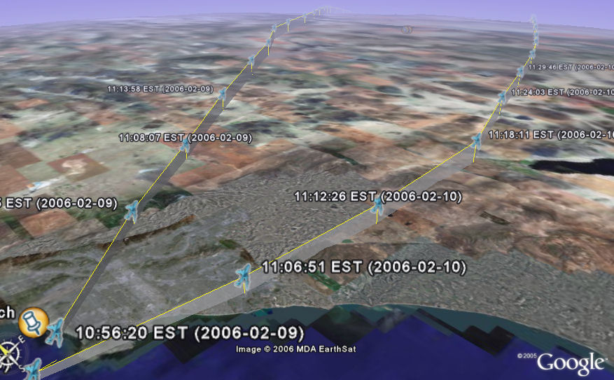
In addition we offer Google Earth support for these airplane traces. Just right-click the "Download GE kml"-Link, save the file to disk and fire up Google Earth to display past flights including height profiles!
The new version shows a beta preview of this feature for some selected flights to Boston.
Above is a screenshot of GE showing flights of AAL222 in Google Earth near Los Angeles.
Misc additions:
- Cheapest Fare information. Click on a flight in the menu on the left to show information about cheap fares for the selected flight. You have to enable this service in the "controls". Using data provided by http://www.farecompare.com/
- Support for zooming the map using the mouse scroll wheel
- Tracking of a flight (small "T") leaves a trace of the flight
- Nexrad support. Shows present precipitation. We are working on showing the flight locations more visible when using the Nexrad type. Using data provided by the Iowa State University Department of Agronomy. More Information about Nexrad is here
Subscribe to:
Posts (Atom)